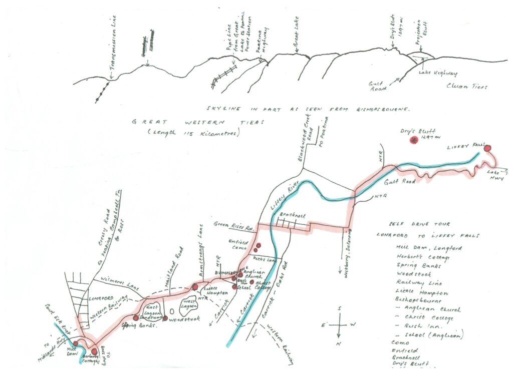
Longford to Liffey Falls (52kms) via Bishopsbourne & Bracknell
Experience
- Outstanding scenery that constantly changes throughout the trip
- Farmlands with varying crops, cattle and sheep
- Two centuries of history, centring around free settlers, convicts and bushrangers
- A large variety of birds and animals living in their natural habitats
- Spectacular mountains and valleys, rainforest and waterfalls
Just follow the route map……. points of interest are listed to comment items.
General
The Norfolk Plains area, which the tour passes through a portion of, is amongst the earliest settled areas in Tasmania dating from around 1807. With Longford at its centre, it covered a vast area of 1,500,000 acres of mostly flat land, at an earlier time being the floor of a large lake. It received its name due to more than 40 Norfolk Island families being resettled in the area, between 1808 and 1813, particularly along both banks of the South Esk River mostly north of Longford, or Latour as the town was known as until 1833.
The people of the “Plains”, as the area was commonly called, were eventually made up of several different backgrounds –
- Aboriginal peoples
- Free settlers
- Convicts
- Norfolk Islanders
- Selected Immigrants
- Bushrangers
Aboriginal peoples
Aboriginal people had lived in this area for thousands of years prior to European settlement and are the traditional custodians of the land. At the time of settlement, the Norfolk Plains area was a favourite hunting ground for three Aboriginal groups:
- The Tyerrernotepanner people (known to colonials as the “Stoney Creek tribe”) which were mostly found to the south and were a strong group under their elder, Eumarrah
- The Letteremairrener people (known to colonials as “Port Dalrymple tribe”) who sometimes extended their territory to include the areas around Longford, Perth and Westbury; and
- The Panninher people (known as the “Penny Royal Creek tribe”)
The country was lightly timbered and well grassed and abounded in game. Although the aboriginal peoples had largely disappeared by 1830, evidence of their existence remains by way of stone implements that are to be found throughout the area. Flint quarries were to be found to the south of Ross and in the north at Native Point near Perth.
Other reminders come by way of several places being given Aboriginal names, Toiberry, which means “ashes”, Poatina “a cavern” and Quamby, “a place of rest or good camping ground”. Also, some people of the region can trace a forebear to these original occupants.
Free settlers
The free settlers fell into two classes, the first being made up of those possessed with capital and were given large land grants in relation to the size of the capital introduced. The other free settlers came with view of bettering themselves, attracted by the good opportunities that the Colony presented, with many being possessed with little more than hope and a willingness to work hard and long. Many applied for and received land grants, but mostly of small acreage. Others who received grants of a significant size were those who had given good service to the Government. The grant system had mostly come to an end by 1830 although a few grants continued to be made until around 1840.
Convicts
Convicts for the first 20 years formed the largest group of the population. Van Diemen’s Land, as Tasmania was then called, received over 67,000 convicts, mostly from England, between 1803 and 1851 when transportation ceased. At its height about 5,000 convicts a year were received. Most were assigned to Government works or free settlers. Sentences were usually either seven or 14 years depending on the severity of the crime. The population count in 1838 recorded 18,000 convicts and 28,000 free settlers.
When it was decided to close down the Norfolk Island settlement, the people were divided into two groups, one group being sent to the north of Van Diemen’s Land and the second to the south and resettled at Sandy Bay, Sorell and to the area along the Derwent River that became known as New Norfolk. At transfer the settlers were given land grants, which at Longford was mostly between 40 and 60 acres, with the Government also providing tools and provisions for up to two years.
Selected immigrants
A number of other immigrants arrived, particularly in the 1850’s, instigated by a Launceston based Immigration Society. At the time due to a large exodus of people from Tasmania to the Victorian gold rush and a big increase in demand for food stuffs and other essentials by the gold diggers, there was a significant shortage in skilled labourers and tradesmen. Needed were blacksmiths, wheelrights, carpenters, joiners, ploughmen and house servants. As a consequence the Society sent a representative, the Rev.Benjamin Drake, to England to locate suitable emigrants. Most of those persuaded to come were from Norfolk and Suffolk. On arrival they were guaranteed work and housing. A number of people living around Bracknell and Liffey can trace an ancestor to these emigrants.
Bushrangers
The Norfolk Plains area is now a peaceful and tranquil place but this has not always been so. In 1825, it was reported that there were over 100 bushrangers (mostly escaped convicts) mounted on good horses and bristling with firearms, scouring the countryside. Murder, robbery and burnings were everyday affairs. Often farmers worked with a gun tied to their plough handles or kept one or more nearby at the ready. In fear, many residents left the area for the safety of the larger towns.
Bushrangers made a number of raids in the Bishopsbourne area. On one occasion they raided the “Bush Inn” and kept all the neighbouring houses in a state of terror for a period while they recovered from the effects of the hotels “gut bender”, the beverage no doubt obtained without payment.
The report of another raid comes by way of a news paper clipping held by the late Mrs. Field of “Enfield”, Bishopsbourne. ‘On November 2, 1832 the bushrangers, Britton and party, made their second appearance at Mr. Field’s western stock station on the Liffey. Unfortunately young Mr. Field was there that night and they robbed him of a handsome gold watch (the gift of his father and his first watch) and also what money he had, amounting to a few pounds. They took away a large quantity of beef, 100 lbs. flour, tea, sugar and tobacco, and they took a new pair of boots off the feet of one of the stock riders. – I think Bill was his name – said it was a shame to take the young master’s watch, and for that Brown knocked him down with the butt of his gun. They took their swag away upon one of the stock horses”.
(Reports state that the watch was later returned, because their conscience smote them)
Brady’s Lookout, a peak on the Western Tiers overlooking Norfolk Plains, was named after the bushranger, Mathew Brady, who used the vantage point to spy on the activities of the area below.
Farming
During the 1800’s Norfolk Plains was known as the granary of Australia, producing large quantities of first class wheat, which was much sought after and exported to New South Wales, Victoria and England. At Longford four flour mills were kept busy grinding wheat into flour.
Due to this activity and the needs of the farmers, numerous blacksmith shops and machinery makers sprang up at Longford and the surrounding towns, making ploughs, harrows, carts and wagons, also harness for the large number of horses in the area.
Wheat growing gradually declined due to the depletion of the soil and other grain growing areas being established on the Mainland. This was replaced by live stock and other crops, barley, oats, blue and grey peas and flax. With the coming of the Cressy-Longford irrigation scheme around 1970 bringing water from the Great Lake, other crops were grown, green peas, beans, corn, potatoes, onions, opium poppies, brassicas, truffles and specialized seed crops.
Sheep, cattle and horses
These may be seen throughout the region and have been an important part of farming operations since settlement, producing wool, meat, dairy products and horsepower. Over the years numerous stud stock enterprises have been carried out with the progeny being exported throughout Australia and overseas.
Two or three kilometres beyond Bishopsbourne on the road to Bracknell, three adjoining properties conduct stud operations, with their animals often being seen grazing in paddocks beside the road. At “Como” is the well known Richmond Hill angus cattle stud as well as their poll dorset and southdown sheep studs. Another angus stud is to be found at “Enfield” with the next property on the left running a Clydesdale horse stud.
Before tractors came into use on farms, for more than 100 years, draught horses provided the main power in agriculture. In this region the Clydesdale breed was the most popular. Even as recently as the 1950’s, these 15 cwt. plodding giants, harnessed together in teams could be seen working in paddocks, pulling various farm implements, as farmers worked their land and planted crops.
The majority of the earliest sheep came from Norfolk Island when that Colony was closed down and moved to Tasmania. Many of these sheep came to the Norfolk Plains area where they thrived and formed a base for the Tasmanian sheep industry. From about a thousand sheep arriving around 1805 by 1820 the flock had grown in number to 200,000. Large numbers of these sheep were shipped to Victoria, South Australia and Western Australia when those States were settled, helping to establish the sheep industries there.
Fauna
The area is rich in bird and animal life with a noticeable increase amongst a number of species in the last one to two decades. The king of the air is the wedge-tailed eagle and although not plentiful, can at times be seen soaring at great heights often being followed by a flock of crows. From wing tip to wing tip the eagle can reach six feet across and can easily carry off young lambs and rabbits. Hawks are more often seen , swamp and sparrow species. More common still are the two varieties of plovers, magpies and gallahs. Other birds frequently seen are cockertoos, parrots, minors, wattle birds, kookaburras, wrens, robin redbreasts, swallows, crows and currawongs. Around the Lagoons and other waterways, are black swans, cranes, cormorants, mountain and wild ducks, Cape Barron geese, native hens and bald coots.
In addition there are a variety of imported birds, most quite plentiful, goldfinches, sparrows, starlings, blackbirds, skylarks and quail.
At night the nocturnal species come to life, including barn and screech owls, mokepokes and small bats.
Many of the native animals are also nocturnal and consequently are rarely seen during daylight hours. At night with the aid of a torch or frequently in the beam of a vehicle light, these animals are seen, kangaroos, wallabys, pademelons, brush and ring tail possums, wombats, Tasmanian devils and members of the quoll family, generally known as native and tiger cats.
Several of these birds and animals are endemic to Tasmania. During the day echidnas, snakes (tiger and copper head), lizards, rabbits, hares and bandicoots, as well as a variety of butterflies, moths and insects are out and about.
In the South Esk, Liffey and other rivers and streams, trout, perch, tench and black fish, as well as eels are present. Platypus also live along these waterways but being a shy mammal are not often seen.
And if out at night, the Southern Lights may also be visible on a dark clear night, particularly during the summer months, its white shimmering light hovering in the southern sky with pink and white shafts of light shooting up from the horizon, piercing the darkness.
Longford
Mill Dam
A popular fishing, swimming and picnic area adjacent to the Longford township. Vehicle access is via the Tannery Road which runs off the Illawarra Road. It can also be reached by a more direct walking track which crosses under the highway near the Longford junction.
The dam was built in the mid 1840’s by John Badcock, a Cornish immigrant who had arrived in 1831, so as to provide a store of water to power his flour mill which he built further down the South Esk River at Newry. The water reached the mill by a connecting water race carved through the intervening ridge. At a later time a generator was installed in the race to produce power for lighting at Longford.
John sold the mill around 1850 to a neighboring farmer, Alexander Clerke, who later still sold it to the Affleck family. The original mill was destroyed by fire about 1890 but was replaced, this latter mill being washed away in the 1929 floods.
Herbert’s Cottage – “Rocky Hill”, Longford
Built by the “First Fleet” convict, John Herbert after transfer from Norfolk Island in 1813. John had been convicted at the Old Bailey, London in 1784 for stealing a silk handkerchief, value one shilling, and sentenced to seven years imprisonment. He was the fifth person to be listed to come to Australia and arrived at Botany Bay, near Sydney, aboard the “Scarborough” on 19 January, 1788, one day ahead of the main fleet. He was soon sent to Norfolk Island where he finished out his sentence, afterwards becoming a constable and a farmer.
John received a land grant of 50 acres and his son James who transferred at the same time, also 50 acres, the properties adjoining.
When one of the churches at Longford was being built around 1830, over 500 loads of stone were carted from the Herbert property quarry. Also around the same time the Westbury Road, South Esk River bridge, later known as the Long Bridge, was built, together with a poll house and other out buildings, with the bricks used in their construction being baked on the property.
Woodstock
The substantial homestead which from the road can be seen in the distance beside the East Lagoon wild life sanctuary, was commenced around 1835 by Horace Rowcroft. In that year he had moved from Hobart taking up the position of Chief District Constable at Longford.
The current owner in recent years during late January, has conducted a music festival at the property with bands and people attending from throughout Australia.
Western Railway
The line that can be seen adjacent to the road near “Woodstock” and “Little Hampton” forms part of the first major line built in Tasmania. Opening in 1871 it travelled between Launceston and Deloraine, a distance of 45 miles. The gauge was then 5 feet 3 inches but reduced to 3 feet 6 inches after the line was taken over by the State Government. It was built to enable the easy carriage of food stuffs and passengers from the fertile regions that it passed through. A train could travel between Deloraine and Launceston in about two hours a vast improvement on that of horse and wagon, which took up to two days and some times even longer in wet weather. At that time the roads were generally atrocious having deep holes and often wet and boggy for nine months of the year.
The builders and operators of the line experienced a number of difficulties, not least of which was financial. The farmers, merchants and others in the vicinity of the line had agreed to fund losses should these occur and which commenced almost immediately. A levy was decided upon and called for, with demand that payment be made in two installments. The first installment was met grudgingly but when demand for the second payment was received, those due to pay refused in mass. By 1874 the bailiffs had been called in and much property seized, the stock in trade of merchants, farmers stock and machinery, artisans tools and peoples furniture including a baby’s cradle. The people of the north were incensed, particularly as the Government had fully backed the Hobart to Launceston line, which was in the process of being built, with a levy being applied on all Tasmanians but had refused to assist with the Western Line losses.
Rioting broke out in Launceston which the police could not control. Help was sought from the fire-brigade but was refused. At last an armed contingent was sent from Hobart with the serious threat that a gun boat would also be sent in, bringing order once more to the town.
The bailiffs’ instructions were to sell the seized goods at auction. In one memorable instance the goods were advertised for sale at Bell’s Mart, Charles Street, Launceston. Brian Chamberlain in his book, “The Launceston Western Railway, 1867 – 1904”, continues the story in the following graphic terms. ‘However, when the people were assembled there and the sale was about to begin, six men dressed in black as undertakers, wearing black gloves and grim expressions, with black crepe on their tall hats, walked into the sale room. On their shoulders they carried an empty coffin and on its lid lay an axe. Their leader let it be known that the first person to bid in the sale would be beheaded and carried away in the coffin. No sale took place that day. Furthermore, in general opposition to the Government’s seizure of personal property, 22 Justices of the Peace in the North resigned their commissions.”
The rail line is now part of the State grid with much traffic passing along the line, connecting the Northwest Coast with Hobart, Launceston and George Town.
Little Hampton (Villa)
The property was established in 1826 when Lieutenant George Briscoe Skarden RN received a location of 2,000 acres in the area, naming it after his home area in England. The original home (now demolished) was commenced soon after together with numerous other buildings, including accommodation for his assigned servants.
Skarden also operated as a local magistrate and took a keen interest in education and the church. Two rooms of his house were set aside for regular services conducted by the Longford rector, or if that person could not get across, the Lieutenant himself would read “Divine Service”. The people of the Villa and surrounding areas were summoned to church by a bell he had erected. In 1844 he presented the bell to the new church at Bishopsbourne and which still rings out before worship. One side of the bell is inscribed with the date, 1836.
He sold the property in 1844 and moved to Westbury where he died on 15 September 1850, aged 65 years.
Although never declared a town, the name Little Hampton lives on, with the property now greatly reduced in size, still bearing the name, also the Government land division for the area being called Parish of Little Hampton. The Methodists relocated a church to a corner of the farm in 1887 and it became known as the Little Hampton Wesleyan Methodist church. This building erected nearby at Maitland around 1860 still remains, but as a private residence since the mid 1970’s.
Of some interest if not intrigue, was that the postal people called the district Toiberry while the rail station was known as Little Hampton. They both operated out of the same building – one could send a letter from the Toiberry Post Office and buy a ticket from the Little Hampton Station and not leave the same counter.
Bishopsbourne
The town received its name in 1845 when the first Anglican Bishop of Tasmania, Bishop Nixon, purchased part of the “Vron” property, 1,218 acres, for purpose of establishing a theological college and township in the area. The town boundaries were established in 1848, with Bishopsbourne being declared a town on 3 July, 1866.
Further land, 3,400 acres, was purchased by the church at a later time, at a cost of 10 shillings per acre, taking their holding to around 4,600 acres. This was let out to tenant farmers but later sold off , the last farms being sold in 1938.
In the late 1840’s early 1850’s, a builder William Webb, erected around 14 homes in the township. Several of these homes built out of local pit sawn timber and hand made nails and with mortised joints held in place by small wooden pegs, still survive but have been modified over the years.
Other buildings in the town and immediate area, past and present, have been three Methodist, Anglican and Seventh Day Adventist churches, police station, four blacksmith shops, two hotels, two schools, Anglican which was later taken over by the Government and a small private school, coffin maker, Government pound, smokehouse and bacon factory, a community milk separator, reputedly the first in the Southern Hemisphere, shop, post office and telephone exchange, former public hall, now a private residence, and a new Community Complex located at the Recreation Ground. A number of contractors lived in the town also a district nurse come midwife.
One of the difficulties for the residents of Bishopsbourne was the lack of a good water supply, and was probably a significant reason for the demise of the town, however this was changed when a channel from the Cressy-Longford irrigation scheme reached the town in 1976. Renewed development has been evident since then.
Sporting activities have been a strong feature of town life, horse racing, competition ploughing, road cycle racing, cricket, football, badminton and indoor bowls. Regular sports carnivals which included the events of foot running, cycling, wood chopping, novelty events and sheep dog trials for many years drew large crowds the last being held in 1988. The Centenary Sports were held at the old College oval in 1946. Several noted sportsmen have grown up and lived in the area, Mick Goss who was the World champion two mile runner in 1941 in a time of 9 minutes 11and 2/5 seconds, Trevor Brooks, the first Tasmanian to win the Warnabool to Melbourne bike race and Keith Badcock who won the Burnie Gift foot race in 1970 and was Tasmanian Track champion in the same year.
The Bush Inn, Bishopsbourne
Built before 1842 out of locally convict made bricks by William Webb who in 1848 became the first licensee. Also in the grounds was a banquet hall and skittle alley, both of which have now disappeared. The hotel was the centre for much of the social activities of the community and surrounding areas. When the reapers and the shearers came into town things often became very lively some lying drunk and being abusive to passersby along the roads outside the hotel, so much so that many travellers took a side road around the town. A popular drink at that time was called “gut bender” a type of rum.
The hotel was later converted to other uses, variously operating as a shop, post office and telephone exchange and is currently a private residence. It was substantially rebuilt after a fire in 1970.
Another hotel the “Forest”, a wooden structure is stated as standing opposite on the Longford road, but was destroyed by fire more than a century ago.
Church of the Holy Nativity, Bishopsbourne (Anglican)
The foundation stone was laid on Wednesday, 9 October 1844, by Bishop Nixon and opened the next year on 25 April, 1845. The cemetery contains many of the early pioneers including many children who died from epidemics that periodically swept the area. It is said that an entire family of seven children died at Armstrongs Lane with the parents then proceeding to have seven more children.
Bishopsbourne School
This was built in the late 1840’s by the Anglican Church following a petition containing 75 signatures presented to Bishop Nixon during his 1844 visit. The parents offered to help with their children’s education to the extent of sixpence a week per child. The school was later operated by the State Government continuing until 1955 when the school was closed. The Church sold the property in the 1960’s and is now a private residence.
Christ College, Bishopsbourne
The College was established at the former “Vron” property mansion, to be found about a kilometre west of the township, after purchase of part of the property by the Anglican Church. To make it suitable for its new purpose alterations were made and additions attached. The double storied residence had been built between 1826 and 1829 by William Guillyer Walker who had arrived in 1825 and had received the property of 2,896 acres as a grant. Other buildings included brick stables, coach house and an octagonal shaped chapel. The cost of the mansion and the attached 1,218 acres was five thousand pounds.
The only evidence of the property now are the many massive oak trees that stand around the grounds of the former mansion and college and some foundation stones pushing up through the earth. Some of the bricks may be seen at the towns Recreation Ground used in the construction of two outside toilet blocks. Other bricks were used for road fill on the property.
Christ College was opened on 1 October, 1846 the culmination of a number of years of effort in getting the complex up and running. As far back as 1833 Governor George Arthur, the first Tasmanian Governor, had been keen on the project and did much to promote it. A later Governor, Sir John Franklin and his wife, Lady Franklin, continued these efforts. The plan envisaged was for the college to correspond as nearly as possible to a college in the Universities of Oxford and Cambridge in England. After a lot of effort and difficulty the necessary funds were raised and the services of a warden obtained, that of the Rev. J. Phillip Gell, from Trinity College, Cambridge.
In 1855 there were 42 students in residence with the prize list at the end of that year revealing some of the names, Pedder, Davies, Arthur, Mason, Dumaresq, Bedford, Gates, Denison, and Pitcairn all of whom were later to be noted as occupying places in the States history. Three students trained at the College later became Archdeacons – they were the Ven. Peter Righton Atkinson, of Surrey, England, the Ven. Peter Parry Fogg, of Natal, South Africa, and the Ven. Alfred Nathaniel Mason, of Hobart. Chief Justice, Sir William Lambert Dobson, K.C.M.G., was also trained at Bishopsbourne as was the church historian, Ernest Whitfeld.
The College closed after 11 years due to a lack of finance. A difficulty was to find enough suitable students to make the college viable. After a lapse of 22 years the college was re-established at the University of Tasmania, Hobart under its original name, Christ College, where it still continues today.
Dunbell (now Glenfield and Como)
When the census of 1842 was taken the owner was stated as being Charles Arthur, with leasee for the now “Glenfield” section being John Badcock who soon after built the Newry flour mill previously mentioned, with the “Como” section being leased by William French a brother-in-law to John Badcock. On census night 34 people were living at the “Dunbell” property, of which 12 were either convicts or former convicts.
Charles had previously worked as a private secretary to his uncle, Governor George Arthur, but on leaving that position had moved to Longford where he was appointed Police Magistrate for the district, serving in that capacity from 1836 to 1862.
At the census the “Glenfield” house was noted as being of timber and complete, with the “Como” house being brick and incomplete. Both houses, as with the other houses on the property, have since been demolished although the brick stable at “Como” remains, now used as a garage.
A new timber house was built at a later time at “Como” by a new owner William Dodery, which still exists, although over the years has been renovated and added to.
Dodery was prominent in civic and Government affairs, serving as a member of the Longford Council for 20 years during which time he was warden on 10 occasions. In 1861 he was elected to the Tasmanian House of Assembly holding the seat until 1870 and then in 1877 was again elected to parliament this time to the Legislative Council. He was a foundation member of the Northern Agricultural Society which was formed in 1856 and was its first treasurer.
Besides the “Dunbell” operation he owned at various times four other farms in the area, also having a new home erected on each property. He was also a noted stud stock breeder which included Lincoln sheep. The Blenheim Hotel at Longford was also built by him.
Enfield, Bishopsbourne
William Field, who became known as the “Cattle King of Tasmania” obtained the property in the 1820’s and soon after commenced the large Georgian home that is still to be seen on the property. Due to a change in road systems the house is now viewed from the rear.
William had been a cattle dealer in England and in 1800 had been convicted for receiving nine stolen sheep from his brother, Richard, and sentenced to 14 years transportation. The trial was held at the “Old Bailey”, London. He arrived in Australia aboard the “Fortune” on 12 July, 1806 and soon after was transferred to Port Dalrymple, Van Diemen’s Land and would have been amongst the first residents of Launceston. He received his freedom in 1814 at the age of 40.
In 1836 William died at the age of 62 just 22 years after gaining his freedom but by this time was a man of considerable wealth, owing about 16,000 acres of mostly first class land in a number of areas of Northern Tasmania, together with vast numbers of cattle, sheep and horses. Besides the lavishly furnished “Enfield” mansion, the family also built a number of other large homes, all two storied, including “Eastfield” at Cressy, “Westfield” at Westbury and “Calstock” at Deloraine. In addition William owned a central block in Launceston, known as “the cattle paddock”, and which was bounded by the present day Brisbane Street Mall, St. John St., York St., and Charles Street. On the block he had several houses, an hotel and a butchers shop. Also in other parts of Launceston he either owned, leased and operated other hotels.
William and family were heavily involved in horse racing, with one particular horse, “Strop”, twice winning the Hobart and Launceston Cups, and running second in the 1868 Melbourne Cup. Through racing and probably through other business activities, William was an associate of John Batman who founded Melbourne.
“Enfield” was sold out of the Field family in 1980.
Bracknell
Although Bracknell was settled some years after Bishopsbourne, it is now the centre for the region. It has two shops, Anglican, Baptist and Uniting churches, hotel, school, post office and supports several cricket and football teams. At the hotel good quality counter meals may be had.
In the past the town was much more of a community and self supporting than now, but like most other towns has, with changing times, lost a number of services and facilities. In the not too distant past two sawmills and two garages operated in the town, there was also a bicycle shop, police station, blacksmith shop, Catholic Church and two resident ministers, a bakery, monthly stock sales, a daily bus service to Launceston, several cartage contractors and the monthly movies which were usually well attended.
All the street signs have female Christian names, given in honor of the early pioneer women of the town. The main street, Louisa, was named after Louisa Boon, wife of Edwin Boon and the mother of 17 children. She was the youngest child of Francis and Mary French of Longford, her father being a farmer and the first Wesleyan Methodist lay preacher in Northern Tasmania. Many of the early pioneers lie buried in the old Methodist cemetery found behind the Uniting Church.
Bracknell is now a mostly dormitory town with those working driving daily to Longford or Launceston.
Dry’s Bluff (Height, 1297 metres)
The mountain forms part of the Great Western Tiers range which is about 70 miles long, with the Bluff dominating the Liffey landscape. For hardy walkers who want to make the steep climb to the summit, on a clear day it offers panoramic views in all direction. Stretching out from the north to the east lies much of the old Norfolk Plains area with its patch work quilt like farms, winding rivers and orderly laid out towns of the “Plains”, the higher suburbs of Launceston and the Tamar River snaking its way to the sea. George Town and the Tamar Heads, some 70 kilometers distant are clearly visible, also a considerable amount of the northern coastline. From the south to the north west numerous peaks are also visible jutting up from the plateau on which they stand. On the way to the top the vegetation gradually changes from rain forest to open woodland on the middle slopes then to shrubby alpine plants near the top.
However as the track is not well defined and there being some high and impassable cliffs, a guide for first time climbers is desirable.
Liffey
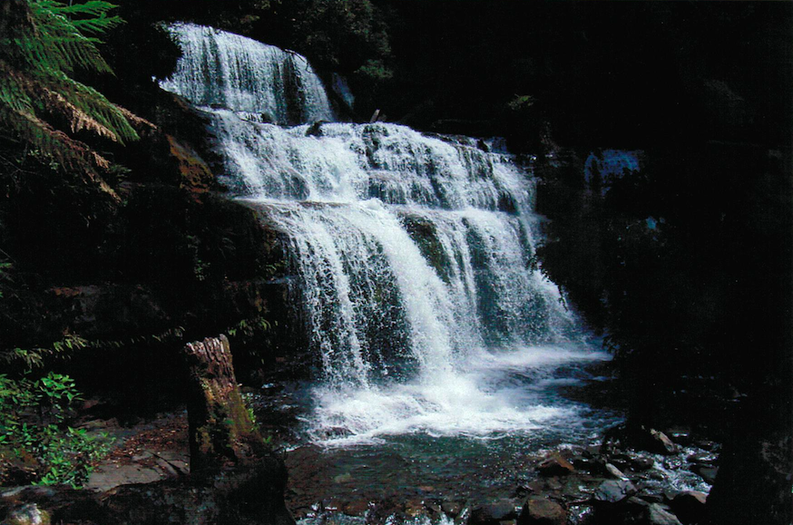
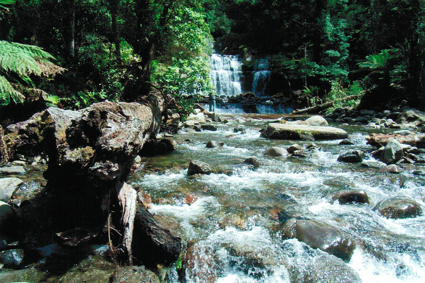
The name has become well known to tourists throughout Australia and to many overseas visitors due to its association with a number of spectacular water falls on the Liffey River. The river rapidly descends the Great Western Tiers mountain range through a steep sided valley, known as the Gulf, and which in the falls area is frequently covered with dense, luxuriant and unspoiled rain forest.
Some of the trees there are huge with one specimen, a brown top stringybark near the Upper Falls car park being about 18 paces around at the base and 165 feet high, and with its top clearly broken off, was once taller still. The path to the tree is sign posted, “Big Tree”, and is less than a two minute walk.
It is said that the hollow butt of one huge tree provided one early pioneer settler with sufficient room to live in on one side and enough room to stable his horse on the other.
The last 12 kilometers of the road to the Upper Falls carpark has a gravel surface but is well formed and is easily passable to short wheel based road vehicles, but being narrow and steep in places, care is required. The road winds through some beautiful stands of rain forest and with the nearby towering mountains and steeply descending valleys only adding to the spectacular scenery.
At the Upper Falls carpark are to be found toilets, tables and a barbecue area, good signing, board walks over wet and steep areas and strategically but discretely placed platforms to enable visitors to gain maximum views of the river, water falls and rain forest.
The area now has National Park type status. Entry is free.